The preamble(!)
You'll remember the occasion. Last year's (2007) AAS pub meet, ahead of the Symbian Smartphone Show.
Julie Wills and I, somewhat rashly, and with a burst of enthusiasm, promised a round-up of native sat-nav solutions for Symbian OS (in theory for S60 and UIQ, but the former had more options). And we (well, I...) mentioned a month as a timescale. That'll give us plenty of time, we thought. LIttle did we know.
Now, this is getting a bit beyond the main point I wanted to make in this editorial, but the last five months can be summed up as a liturgy of frustration. I won't name names and say which is which at this stage, but:
- One company simply never returned our emails.
- One company took a month to respond and then sent us the WinMob version. When pressed, they send an S60 version that was so buggy as to be unusable.
- One company insisted on a ridiculous amount of traditional journo accreditation before they'd release a review copy of a simple, relatively inexpensive retail pack.
- One company's product was quoted as only being for a specific device and was, even then, buggy. When pushed, it turned out to be a beta... that stays in beta until the next year's Smartphone Show, at which point they release the next-gen version, also as beta but with new bugs.
- One company's product is still in beta a year after release, and with more completely different beta versions, depending on the specific test device, all of which are not quite, but almost, entirely incompatible - and confusing.
- One company's heart seems to have gone out of the industry and has shifted focus into car-borne devices.
Meanwhile new solutions have arisen, new devices have been announced with new OS versions, as part of what is, we have discovered, an always changing landscape. It's not like comparing Sudoku games. The final straw was Julie's review device, her beloved Nokia E90, getting bricked in a firmware update and having to be sent away...
[We've now had an extra offer of help on the review front, and the E90 is being sorted out, but, in light of the above, please don't hold your breath!]
Lack of common sense
Yesterday was a case in point, in terms of general frustration with the current 'state of the art' software. Using Nokia Maps 2.0 beta (not wishing to pick on this solution particularly, but it's typical of the breed), my family and I set off from Reading (in the UK) to a wedding in Wimbledon (near, but not really in, London). The software said the journey should take 45 minutes, taking us in on the M4 and then cutting through Chiswick and other suburbs, but, knowing that we were heading somewhere near the capital, I played safe and allowed double that. Just in case. After all, we could always arrive half an hour early and grab a snack or have a look around.
The 30-or-so-mile journey took almost two hours and we missed the first quarter an hour of the wedding, arriving stressed and fed up. We'd experienced congestion, grid-lock, snarl-ups at complicated junctions, 'normal' heavy traffic through numerous High Streets, and much more, all along the route the sat-nav software had helpfully hand-picked as the 'fastest'.
Two hours later, leaving the wedding, I decided to use a little common sense of my own and wondered about ignoring the sat-nav's best route and simply striking out south-west, directly away from London, for a few miles and then letting the software pick up a new best route home, avoiding its original choice (M4 etc).
Within a staggeringly short five minutes, we were cruising along an almost empty dual carriageway (the A3) and Nokia Maps had calculated a new route (via A3/M25/M3/A322, for locals who are interested!) that turned out to get us home in a total of 55 minutes, less than half the previous leg of the journey.
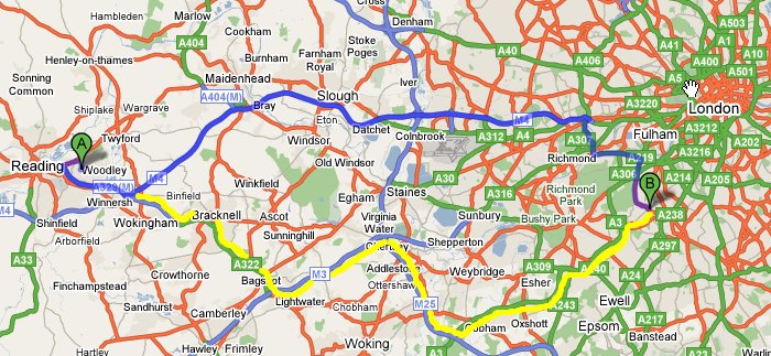
Dark blue: typical sat-nav/computer calculated fastest route
Yellow: real world 'much faster' route!
Two hours down to 55 minutes? The latter is slightly longer than the original (M4) forecast of 45 minutes, but it's a heck of a lot less than the real world journey time.
The problem is, of course, that even in 2008, satellite navigation software still hasn't got any common sense. You really would have thought that by now, with a decade of experience behind them, developers would have thought to have included some recognition of the fact that, in daylight hours, major roads into major cities get - and I'll phrase this delicately - full of traffic.
With all the other calculations that sat-nav software now performs, including applying 'fudge factors' to specific road classes and taking into account major reported traffic 'incidents', should there not be an extra, perhaps even time-specific, factor that the software would apply when considering routes heading in the vicinity and general direction of big towns and cities? Calling it another 'fudge factor' would sound a bit amateurish. What about 'Urban Congestion Allowance' (UCA)?
In the case of our journey to Wimbledon, the software would then have considered the roads it was asking us to take, would have spotted that the time of day was 10am (and not midnight, for example) and would have thought to itself, 'Hmmm, these roads are going to be pretty busy, I wonder if there's an alternative'. The software would then re-examine other slightly longer (theoretically slower) routes that it had previously discarded and would have found the M25/A3 route into Wimbledon in a fraction of a second. With no known traffic bottlenecks and with absolutely no suburban High Streets to battle through. The UCA would be tiny and the 55 minute route would be proudly presented as my best option.
And we'd have made the wedding with time to spare and would have actually seen the bride arriving and coming up the aisle...
The problem is that most major roads, quite naturally, go to major towns. And major towns have an extensive network of feeder main roads. Again quite natural. However, sat-nav software then leaps gleefully on these roads and gives them equal prominence to all others. When, for much of the day, these so-called major roads are actually slower than a donkey track.
Traffic incident-aware software is a start, but I'd like to see all roads in the Natvteq and Tele-Atlas databases also carry a UCA rating. Then, at route calculation time, the UCA is applied, along with a computerised version of 'common sense', hopefully meaning that more optimum routes are calculated around city and town centres and not through.
I've always said that you should never place total reliance on sat-nav software and should instead at least look at a map book first. If I'd done that yesterday, I'd have done my blood pressure a lot of good and my wife could have had a leisurely pre-wedding cup of tea, instead of arriving late and bemoaning the traffic, the road network planners and the programmers of sat-nav software!
Steve Litchfield, AllAboutSymbian, 13 April 2008
PS. If you've been using a navigation solution which handles general urban congestion better, do please comment. All contributions and feedback welcomed!