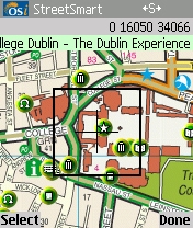
OSi StreetSmart provides the user with detailed street maps and information on hundreds of attractions and places to visit. The GPS compatible mapping application, which uses OSi's latest Dublin Street Guide will greatly benefit tourists and anyone who lives, works or is interested in getting to know Dublin a little bit better.
OSi StreetSmart includes hundreds of searchable Fáilte Ireland Points-of-Interest including museums, historic buildings, gardens, day tours, parks, and top visitor attractions. Each attraction includes a phone number (with click-to-call option), address, and informative description. Users have the option of connecting over-the-air to access photos and extra information on each attraction and to download new POIs.
As well as accessing information provided by Fáilte Ireland, OSi StreetSmart users can create and share new POI and add their own photographs and comments through the over-the-air OSi StreetSmart Information Exchange. This allows contributions to be added by visitors to Dublin, experiences to be shared, and favourite places to be exchanged.
OSi StreetSmart Guide to Dublin will cost €29.99 and will be available for S60 2nd and S60 3rd Edition phones.

OSi StreetSmart allows the user to:
- Search over 10,000 street names and POI names with SMS-like text input.
- Integrate with your smartphone's camera to quickly and simply
- record photos and video clips onto the map.
- Share your experiences by associating photos and text notes with map features and publishing to the StreetSmart online information exchange.
- View and read other peoples postings.
- Use with a GPS receiver to provide a moving map display, search for attractions near your current location, and record your track making it easy to find your way back.
- StreetSmart includes a Data Manager to make it easy to manage your routes, tracks, waypoints, POI, and maps. It's easy to Bookmark locations so that you can revisit your favourite locations at any time.
- See your location against the backdrop of the latest Dublin Street Guide of the city and surrounding area and an all Ireland atlas.
- Create and edit routes and waypoints on your phone, or import from popular PC software applications and websites.
- Brilliant for walkers, runners and cyclists. Record a Track Log so that you can review your performance, including parameters such as time taken, maximum and average speed, track length etc.