This is the data collection system which will be used to create the next generation of digital maps and shows an indication of what sort of map data and visualisation models we can expect to see. As you'll see, it is a very significant advance over anything available today.
Here's what Navteq say about the system:
“The NAVTEQ True system will allow us to collect and process advanced data of the highest quality on a larger scale, faster and more efficiently,” stated Cliff Fox, executive vice president, NAVTEQ Maps. “NAVTEQ’s customers will benefit though our ability to bring an increasing range of advanced data into our maps at a lower cost, particularly that which will support a true 3D map. And we see numerous possibilities in new product development that will help our customers continue to differentiate their offerings and bring consumers unique features supported by the highest quality digital map.”
Navteq True system
The Navteq True system, which is currently being rolled out, includes:
- Rotating LIDAR. It contains 64 lasers that can collect data, up to to a range of around 120 metres, over 360 degrees and can capture over 1.5 million data points a second. It is able to operate at normal driving speed limits. Each data point represents a physical point in 3D space and can thus be used to create 3D models representing the physical world.
LIDAR is an optical remote sensing technology; it sends out laser pulses and measures the reflected return. Analysis of this information can be used to measure distance and obtain information about the target surface.
- Combination of high resolution and panoramic cameras. The combination of the two allow for more efficient data processing, which means the resultant data gets to the market faster. The panoramic cameras "capture an immersive picture of a location to support the production of street level imagery".
- GPS (Global Positioning System) and IMU (Inertial Measurement Unit) combine to ensure accurate location information. All of the information from the LIDAR and camera is geo-referenced, allowing the data set to 'be driven through' recreating the data collection drive on the computer (see video). These sensors also collect slope and curve information.
The LIDAR data can be used to create 3D models (1:40 in video), which can be 'coloured-in' (6:33 in video) when combined with information form the high resolution and panoramic photos which are captured at the same time. Navteq sees this as the "critical platform to move digital maps from 2D to 3D representation".
Navteq's business is to provide this mapping data and associated databases to third parties. They have an extensive developer program (which we'll cover in a later video interview) called Navteq Network for Developers (NN4D) through which developers can gain access to Navteq's digital mapping and location products. This means you'll see the fruits of the Navteq True data collection come onto the market through numerous products such as Ovi Maps, Bing Maps, and many others.
Navteq were showing off the raw data. While this will be used to create digital maps and, potentially, the basis for associated 3D visualisations, it is important to note these are not 'end-product' visualisations that you would see in a consumer product.
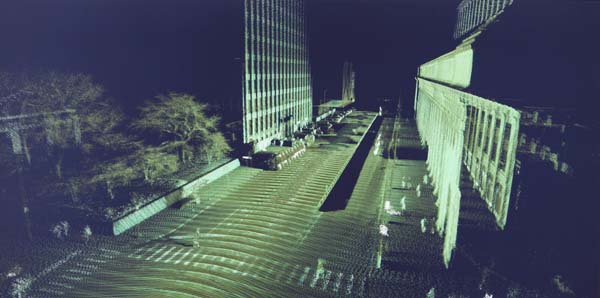
Example LiDAR point data set as a 3D visualisation.
It is important to realise this is about much more than just collecting a 3D model/photographs - it can be used to create the attribute database (i.e. information about certain characteristics of a place and/or area). Navteq collects up to 260 different road attributes, which are an integral part of the Navteq digital map offering.
In the image above you'll note that objects like street markings are distinct (this is a measure of their reflectivity). This makes it easier to identify lane marking and crossings, thus assisting in creating the additional attributes in a data set. For example the system can measure lane width to the nearest cm. It can also be used to identify business shop fronts, street signs, bridge heights, and so on.
Furthermore, it can also be used to collect pedestrian information (sidewalks, overhead walkways, and so on), which is used in Navteq's Cities product. In the video (8:40) you'll also see an example of how a combination of LIDAR and photographs can be used to automatically identify, capture and convert an overhead sign on a road to a digital form, which is used in Navteq's 'Sign-as-Real' product.
Navteq True Demo
Apologies for the quality of the video. We were filming a live video link up with the US (Navteq don't have one of these cars in Europe yet). It is worth persevering with the video as you'll see plenty of examples and get a better understanding of the benefits of the new system of data collection.