Review: Wayfinder Navigator 6
Score:
80%
Version Reviewed: 6.14.2000
Buy Link | Download / Information Link
Back in the early days of the Symbian UIQ-powered P800, well over two years ago, I reviewed an innovative navigation system, Wayfinder. Its key selling point was that, rather than storing all its maps on your local device, everything was handled by Wayfinder's computers at their HQ and routes and maps served up using your smartphone's GPRS connection. In addition to not having to say goodbye to up to 300MB or so of disk space on your expansion card, there was the other advantage that the directions and maps were always bang up to date, covered a very wide area and you never had to worry about using an 'old' product again.
Back then, the disadvantages of Wayfinder's approach were that it was expensive, at £200 or so for every 12 months of use and that the reliance on GPRS made navigation potentially awkward in places where there was a poor phone network signal.
Wayfinder have fixed the first negative, at least, with a 'software-only' product for as little as £60 (100 Euros, for one country) that is for life, not just a year. Much, much better and more realistic. In addition, in the intervening years they've drastically overhauled the product, renamed it a couple of times(!) and made it available for every other Symbian OS-powered smartphone, now including S60 3rd Edition devices, such as the E61 being used here, plus Windows Mobile 5. So whether you have a Nokia 6630, a 9500 or a Sony Ericsson P910i, read on, because the software is also compatible with your smartphone.
The core principles are the same though. Starting Wayfinder Navigator 6 for the first time, you're prompted to pair with a suitable Bluetooth GPS (see their web site for compatibility lists, but most will work fine - I was using a RoyalTek unit) and to choose an Internet Access Point (in my case 'Vodafone Live'), after which Wayfinder talks to the GPS to ascertain position and to its own servers online to grab map portions and to receive calculated routes.
It's worth reassuring you at this point that Wayfinder's not going to run up a huge GPRS/data bill and leave you penniless. Because all the maps used are vector-based (i.e. lines and text) rather than byte-hungry bitmaps, Wayfinder is extraordinarily efficient - an hour's intensive testing only managed to use up 300K of data, according to the Log utility on the E61. Although this could start to mount up, cost-wise on a prepay tariff, those on most monthly tariffs should be able to stomach this extra data use without any qualms.
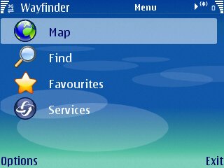
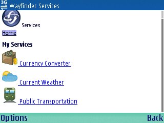
Wayfinder's interface remains as quirky as ever, despite the extra polish to the on-screen graphics and a few extra screen displays. The home screen, shown below-right, shows the way into the program. Just to simplify things, 'Favourites' is what it sounds, a list of favourite locations, while 'Services' is a link to a mobile-friendly web page offering currency conversion and weather reports, though curiously not of the current location - you have to type city and country in by hand. All of which leaves 'Map' and 'Find'. The former is the basic Wayfinder digital map, of which more later, so 'Find' is the way in for almost every use.
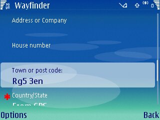
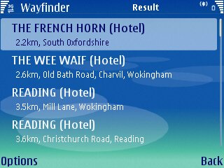
The Find dialog has been streamlined over the years and works very well now, whether you're typing in search clues based on road names or postcodes (full seven-digit UK postcodes in my case), or whether you're hitting 'Options' and choosing 'Select category' to pick a particular Point-Of-Interest database. Once matches have been identified, you pick the right one from the list and bang, you're off and navigating.
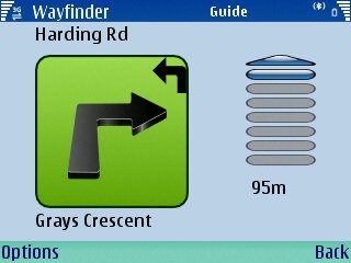
Route instructions are by default presented in a simple 'here's the next thing to do' format, with very clear voice prompts which are spoken in very timely fashion. This is Wayfinder's core functionality and, not surprisingly, they've utterly nailed it. I liked the beep after each successfully navigated junction, confirming that you got your bit right.
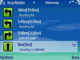
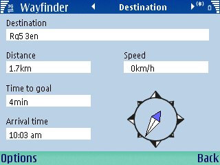
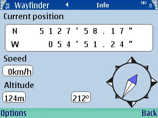
Once under way, it's relatively easy (once you know the trick) to press left and right on the navigator to switch between various views. 'Itinerary' lets you preview the junctions coming up (four at a time), 'Destination' gives an overview of distance and time to your destination, along with a compass rose and speed, while 'Info' keeps the rose and adds altitude, heading and lat/long position to the nearest arc-second. Impressively, the voice prompts work perfectly whichever mode you're in.
So far so good, but you'll have spotted that there's no mention of any maps yet, other than that map mode from the opening screen. Although not implemented as an extra display mode in the same manner as those above, each mode has a 'Show...' menu option, whereupon Wayfinder's vector maps get called upon to show either a portion of your route or simply your current location. This slightly odd hierarchy of screens does take some getting used to, but in truth I was buzzing around the application pretty quickly and it's not significantly harder to use than any other navigation program, all of which seemingly have their own idiosyncrasies.
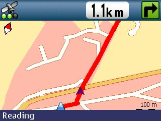
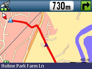
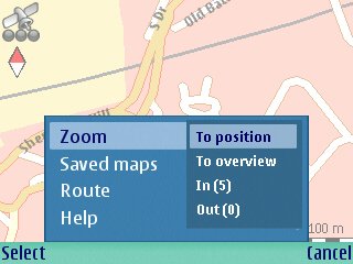
Again, critically, voice prompts carry on perfectly when in a map view. This scales itself on the fly, depending on your speed, so that the detail level is always appropriate, a novel idea but one you again have to get used to. You can manually zoom in or out using hotkeys but after a couple of seconds the display annoyingly reverts to the standard zoom level.
You'll note the maps are all top-down, i.e. two dimensional. While this would have seemed pretty darned cool ten years ago, we've become spoilt by the '3D' real world displays used first in TomTom products then copied by every other navigation system since. Going back to 2D is, if I'm honest a little disappointing. It's not just cosmetic, 3D displays show you the world as you're seeing it through your windscreen and this makes it a doddle at confusing junctions to pick out the right path - with a 2D display (which is automatically swivelling to keep up with your current direction) it takes significantly longer to work out by eye which road is which. The maps aren't helped by some poor choices in colour scheme, with major routes in a yellow ochre that's just about invisible when viewed on a smartphone screen in sunlight.
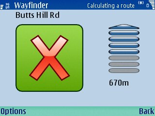
If, at any point, you stray from the calculated path, "You are off-track" sounds out, with automatic recalculation thankfully being the default. There's then a short delay of 10 seconds or so and you have a new route calculated at Wayfinder central.
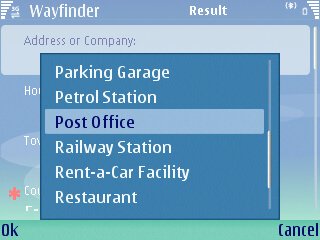
In addition to street-level planning over your selected regions, there's also a good set of POI categories. Unlike many rival systems which have categories for show and then fail to populate them, Wayfinder's are realistic in number and capacity and I was able to correctly get to my nearest hotel, petrol station, railway station, and so on.
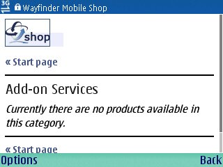
Apart from the basic navigation functions, Wayfinder Navigator 6 has extras popping out of its seams, though not all are fully realised. There's a traffic information service, though you have to pay for this after the first month, plus a 'Mobile shop', for mobile-friendly purchasing of Wayfinder, including one-month access to extra regions for a small fee (15 Euros), presumably for use on trips. And there's the aforementioned 'Services' web page and shown below.
Because Wayfinder handles all your route requests online, there's also scope for their 'My Wayfinder' service, accessed using your desktop computer, in which you can draw together your various routes and pass on details to others. Corresponding 'Load' and 'Save' options within the application mean that you can have favourite routes, not just favourite locations. There's apparently even scope for downloading small local maps, to save GPRS dependency and costs, although I didn't try this. 'My Wayfinder' is certainly an excellent way of adding value to the core product.
One interesting aspect of the online authorisation scheme is that you can switch to using Wayfinder Navigator on any other compatible device (most S60/UIQ phones, plus those running Windows Mobile 5) and then back again. And then onto yet another device. As long as you re-enter your Wayfinder login details on each installation you can use it on as many devices as you like (as long as you don't try it on more than one at a time, obviously!)
Whether Wayfinder is the navigation system for you depends on a number of factors:
- Whether or not you already own a Bluetooth GPS
- How often you travel off the beaten track, in areas where network coverage is weak (I can think of several areas in the South West of the UK where I can't get a GPRS connection)
- Whether you'd find it useful to switch devices often
- How important it is to you that maps are bang up to date
- How important it is to you to have a 3D point-of-view display
Wayfinder Navigator 6 is certainly an option that's well worth considering and full credit to the developers for delivering a unique system that's stable, attractive and professionally realised.
Reviewed by Steve Litchfield at