Review: Nokia LAM GPS Module
Score:
78%
Version Reviewed: 1.x
This is commercial hardware that comes bundled with TomTom RoutePlanner and TomTom CityMaps software. The package contains:
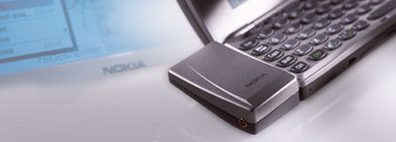
- GPS module
- Carrying case for the module with belt loop
- GPS extension aerial (~3m long)
- Double CD package containing:
- 1 x TomTom RoutePlanner CD
- 1 x TomTom CityMaps CD
- Installation leaflet

Cost: £235.00 (purchased from www.expansys.com)
Installation:
Installation is straightforward; simply hook up your 9210(i) to the PC, plug the GPS module into the bottom socket of the 9210, insert one of the TomTom CDs into your PC and follow the instructions.
- Insert TomTom RoutePlanner CD, select language, install application.
- Add support for GPS.
- Add country maps.
- Insert TomTom CityMaps CD, repeat (1).
- No need to repeat (2) so add location maps. When a location is selected, the application automatically installs all the locations in the surrounding area. These are all standard .sis files and self install.
One minor gripe is that you have to return to the main installer menu for each new location you wish to install. There is no option to pick several locations at once and install them in one hit. There's a fair amount of data to transfer and it takes a while.
The installer offers the option of installing on C: vs. D: - this is a no brainer - install on the memory card every time, because this app needs a chunk of memory, i.e.
RoutePlanner App: 470kB
UK RoutePlanner map: 4.6 MB
CityMaps App: 650kB
London area city map: 5.3 MB
Southampton city map: 580kB
I would recommend a minimum of a 64 MB MMC for anyone who travels around and doesn't want to keep moving location data between 9210 and PC. There are options to install maps with less detail to save memory.
Starting the program:
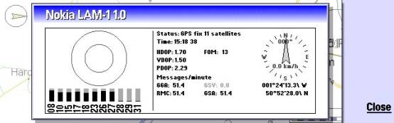
This is a doddle. Simply plug in the GPS Module and, if required, extension cable and open the required application. If necessary, select the map for the area you are in and wait for the GPS to identify your location. This can take a couple of minutes and partially depends on the number of satellites that the GPS can sight. There is a utility under the GPS menu option that shows the detail of the current satellite data available…
The software is fully functional in all other respects when the GPS is either not attached or has no signal.
Using the program:
There are a lot of menu options and settings to consider. Despite this, the program is pretty intuitive. I invested 3-4 hours up front installing the software, testing the views, trawling through the menus and playing with the settings. Since then, I've just used it.
My initial view is that the system well exceeded my expectations. With the right amount of information on the screen (the display is much smaller than a page in a street map) the text detail is not as sharp as you would get on a paper map, but it is pretty good.
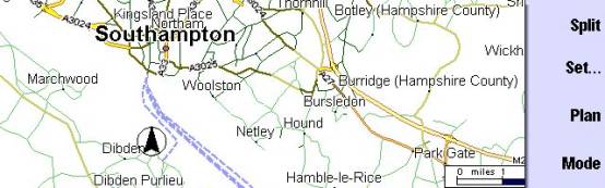
The mapping information is stunning and the data on the TomTom CDs is comprehensive. You would need a suitcase to carry the necessary paper atlases around. RoutePlanner offers a similar level of detail to a national road atlas. The UK version covers 18+ countries in Europe. CityMaps offers similar detail to a street map when zoomed right in. The UK version covers towns and cities in 13 countries in Western Europe.
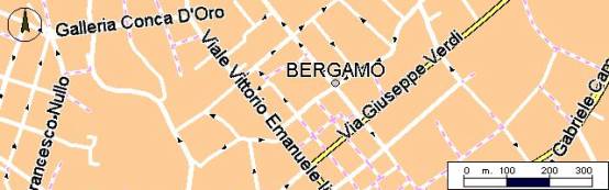
CityMaps give zoom capability all the way down to names for very minor roads. The zoom range is:
| Max | Min | |||
| RoutePlanner, | 1 cm = | 1km | > 500km | |
| CityMaps, | 1 cm = | 30m | > 8km |
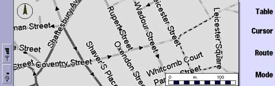
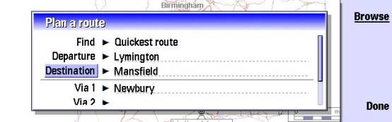
The TomTom s/w delivers full route planning capability. CityMaps behaves the same way as RoutePlanner, shown here….

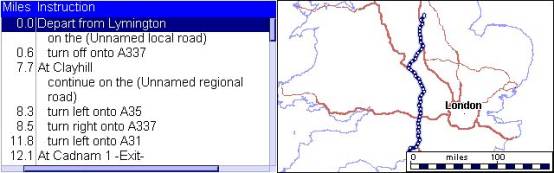
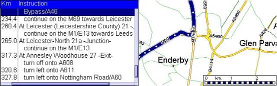
On the move, the GPS continually updates the position. The arrow in the circle shows your GPS position on the map and direction of travel. The map view automatically adjusts to display the current location. There are several heads-up orientations available as options for the display.
The GPS positioning integrates seamlessly with both RoutePlanner and CityMaps. The update rate settings can be defined by the user. The GPS works at least as well as an 18 month old handheld GPS unit I have. The positioning is accurate down to a few feet. It deteriorates slightly if the GPS can't get a good fix on enough satellites.
The aerial extension is surprisingly useful, particularly when travelling in a car. It can also be stuck out of a window if you are in a building. The back of the sensor head is magnetic, helping to hold the sensor in position. The 3m cable length means that the rear parcel shelf is a potential location. A piece of Velcro stuck to the back may be a good alternative - I couldn't find anything magnetic on the dashboard of my car.
System requirements:
RoutePlanner uses ~1200 kB of memory with the GPS module active. CityMaps needs ~1500 kB. So you'll need to close down most of your other applications to run both TomTom applications simultaneously.
Power:
The GPS Module is powered from the 9210 so it will affect battery life. Also, use on a journey intensifies the power consumption as the display will be at maximum for prolonged periods. On a 1 hour journey, I used a full block on the communicator power scale, so 4-5 hours is likely to be the maximum duration under heavy use. Fortunately the Lam-1 design allows a charger to be simultaneously plugged into the 9210. Bottom line: get a car charger if you haven't already got one. If you are walking, it may be possible to improve battery duration significantly. The refresh rate on the GPS can be turned down and the display will not draw power when the case is closed.
Complaints / system limitations:
- Most of the limitations are those of the 9210. A bigger, clearer screen would be a major bonus, but that's no fault of the GPS /mapping functions.
- I found that, particularly in CityMaps, the colour schemes don't work that well on the 9210 screen. More contrast would be better, or a different colour scheme. Having said that, my 9210 is an early one and my fiancée's 6 month newer 9210e (currently away upgrading to v4.13, so not tested with GPS yet) has a sharper display with much better contrast. Thus, the display may be much better on other Communicators than mine.
- In CityMaps, you have to manually select the next area as you travel across the boundary between map areas - it does not seem to be able to automatically switch from one to the next.
The final word:
I hesitate to go to print with such a high score, particularly since this is my first review. Trouble is, it does exactly what it says on the packet. It may be that further limitations come to light after more use, but I haven't found them yet. The integration between the TomTom maps and the GPS module is flawless. Apart from the areas identified above, it's difficult to see what else can be done to improve the package.
I wonder if it would be possible to add more software to show attractions, historic buildings, museums, hotels, etc, on the same maps, perhaps at the press of a button?
Reviewed by Rafe Blandford at